Powerhouse, Main Dam and Spillway
Powerhouse
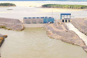
- Length: approximately 120 m
- Operating head (waterfall): about 22 m
- Powerhouse upstream deck elevation: 235.5 m above sea level
- Maximum height above structure’s foundation elevation: 57 m
- Water passages: three intake structures, each with a set of vertical trashracks
- Other installations: south transition structure and service bay
- Service Bay / Intake / Powerhouse building envelope: precast wall panels, metal cladding and roofing.
Turbines and Generators
- Generators: three
- Output: 66 MW each, 200 MW total
- Configuration: vertical shaft, fixed blade propeller turbine with a blade runner diameter of 6.7 m
- Water passage configuration: semi-spiral scroll case in each unit distributes the water from the intake over the full circumference of the turbine
- Turbine discharge: water passes through draft tube and into the tailrace.
- Intake Guides, Gates, and Hoists:
- Installation and “dry commissioning” completed June 2011
- Headgate “wet commissioning” completed September 2012
- Unit 1 inservice date: June 22, 2012
- Unit 3 inservice date: August 22, 2012
- Unit 2 inservice date: October 6, 2012.
Electrical and Mechanical Installations
- Cable raceways, security systems and cabling for the communication system
- The 600V distribution system and equipment
- Heating, ventilating and air conditioning (HVAC)
- Water treatment/wastewater treatment plant
- Fire detection system
- Roadway lighting, civil instrumentation and automatic security gate
- Piping
Spillway
- Location: north of powerhouse
- Construction: reinforced concrete
- Length: 43 metres
- Number of bays: 3
- Vertical lift gates: one in each bay measuring 9 metres wide by 16 metres high
- Peak discharge capacity: about 2,700-cubic-metre per second (probable maximum flood rate)
- Powerhouse and spillway interface: 42-metre-long reinforced concrete non-overflow gravity dam
- Service functions: diversion channel during main dam construction; flood routing for the reservoir during operation.
Main Dam
- Construction: earth and rock-fill embankment
- Overall length: 330 metres
- Maximum height above foundation level: approximately 14 metres
- Crest width: 9 metres
- Elevation: 236.6 metres above sea level.
Concrete Placement
Approximately 120,336 cubic metres of concrete were poured for all structures,
distributed as follows:
- Spillway –11,150 cubic metres
- Service Bay – 16,050 cubic metres
- Intake – 29,000 cubic metres
- Powerhouse – 34,200 cubic metres
- Tailrace – 19,075 cubic metres
- South Transition – 2,800 cubic metres
- Miscellaneous Structures – 8,061 cubic metres.
Below is a link to download the Environmental Protection Plan for the Generating Station.

Click to view or download Environmental Protection Plan –
Generating Station [1MB PDF]